Agricultural Technology Management
Remote Technology Support
- We manage and create work plans to be wirelessly sent to your machines on a weekly, daily or hourly basis. Time is not an issue. Text us on the way to the field and it will be there when you pull in.
- We monitor and assist your operators in the field on how to use the technology via remote display access. A phone call or text and 10 mins of time can go a long way! We also make sure the work data is being recorded and exported before is gets lost.
- We analyze your work and machine data then email you reports at the schedule you would like (Daily, Weekly, Monthly, Etc)
- We can integrate software that will give you the ability to do a POFIT AND LOSS (P&L) SHEET ON EVERY FIELD! This software will also allow you to tie your grain bushels or cotton yield to the CBOT to ensure you are in the BLACK on every single field. When you are not, our data analytics will help you figure out why. NOW THERE IS A REASON TO DOCUMENT YOUR WORK!
- We virtually eliminate the need for employee training on your ag technology. We can remotely set up, operate and trouble shoot any John Deere implement or machine to make sure it is running at 100% efficiency. Employee turnover is no longer an worry, especially the worry about losing money on training sessions because of turn over. Get a good operator, put them in the seat and we ride with them remotely to assist in the operation. This also allows you to upgrade your equipment and technology without the worry of someone being able to operate it.
- We are John Deere factory trained on all Ops center and machine functions.
- Technology purchase consultations. We can give you unbiased advice on what you need, how you can utilize it and how much it should cost. Don't let the dealer sell you a bill of goods you don't need at a price they choose. Our consultations also let you plan for the future with insight on what is coming down the pipe.
- Automated FSA 578 and Insurance paperwork data entry. All the info you need is recorded by your machines. We connect the two automatically.
- We believe your data is yours. A Non Disclosure Agreement is signed and kept on file with every customer agreement. We do not sell your data or share it with anyone you have not approved.
SF RTK Boundary Creation and Machine Calibration
We utilize Star Fire 7500 SF RTK for boundaries with our services but if you only would like to create your own boundaries, we can help you there too. Using our own SF RTK receivers and Gen 5 displays we can wirelessly send your boundaries to your organization for future use.
The boundaries we create are Autonomy Compatible and Guidance Accurate.
We also offer use of our weigh wagon to calibrate your combine yield. This makes life easier and saves time and money. Without having to run back and forth to the elevator or nearest scales to weigh that load out, we can weigh it in the field and have your machine calibrated in minutes, not hours.


Multispectral RTK Enabled Drone Scouting
New to our line up of services for 2026 is areal drone scouting. Utilizing the DJI Mavic 3 drones we can fly missions over your fields and create a multitude of reports and information for your operation.
Spot Spray Rx Maps... After we fly your acreage we can create pixilated variable rate prescriptions for your sprayer to basically turn it into a see and spray spot treatment machine. Being that we utilize RTK on our drones we can pin point weeds down to 1/4" in diameter and locate it within 1-3cm in the field. Once we fly your field we take the drone images and run them through an Ai Engine. The Ai searches every pixle from every image taken, stitches the images together and creates zones that need to be treated with product. I uses machine learning to differentiate the weed images from the crop images based on what we enter in.
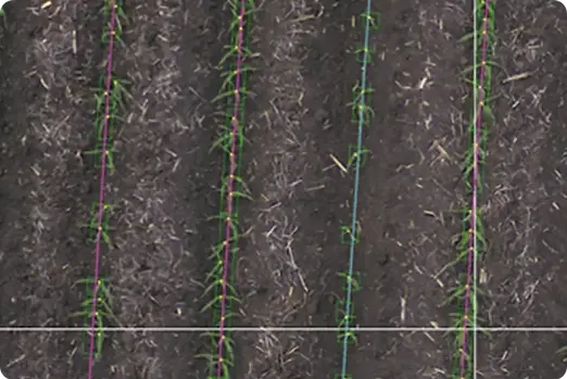
Stand Counts... We know what our planter is planting for population, singulation and skips based off the data the planter is collecting as it travels through the field. The real question is how many of those seed germinated and come up healthy? We can tell you that now. Utilizing the RTK Equiped drones we can fly the acres you planted, run the images through proprietary software powered by Ai and give you a stand count number in the thousands or an emergence percentage. This is valuable information to determine what the yield potential is for the crop and if a replant is neccessary.
Variable Rate Growth Regulator for Cotton... In the world of farming these days we want to save every drop of product we can. We also want to produce the best crop possible as well. By utilizing our drone missions and NDVI imagery we can pinpoint where you need to apply growth regulator and make a prescription map based on that flight. This saves you money at the same time making your harvest much easier and better.
Tassle Counts... The same way and reason we fly your crop after emergence we can also fly your corn at the tassle phase and give you a count of how many plants are available for pollination. This will give you a better outlook on what yield will be in that particular field.
3D Elevation Maps... By flying your acreage we can create 3D elevation maps to give you a better idea of what your drainage is like currently and where and how much you need to change the top layer to make it better. If you utilize Terra Cutta this data can also be used in that system as a survey to allow you to have your grade plan sorted out before you get to the field to move soil.